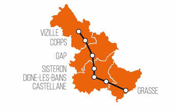

Distance 140km
The Route Napoléon à Cheval© in the Alpes de Haute-Provence is a 140 km route from Peyroules to Sisteron. The altitude ranges from 425 m to 1,245 m. The maximum elevation gain is 20%. The mid-mountain terrain accounts for 60% of the route.
Description
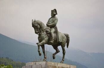
The “Route Napoléon à Cheval” is the first route labeled “Grand Itinéraire Equestre” (Great Equestrian Route)
The Route: After Trébec and the descent towards La Batie, the crossing of the Jabron, which is done by ford, can be very dangerous in winter and during very heavy rain.
After crossing the national road, take the path on the right that climbs through the Sébet hill. It passes near a remarkable restored sheepfold. At La Garde, 1 km after leaving the Rn85, cross the valley with caution. Before Castellane on the Rn85, use the shoulder on the Verdon side as it is wider; work is being studied to avoid this crossing.
In Castellane, cross the bridge over the Verdon, turn left, continue on the GR4 to “La Colle” then the GR406.
At the Col des Lèques, it is possible to stop for the night at the Camping des Sirènes but you can also visit the fossil site of marine mammals (30 mins). On horseback, you must tie your mounts to the trees near the small bridge over the Reissacier ravine (beyond Danger!!).
Take the direction of Senez. Before the junction: Blieux or La Tuilière, see the Milestone, located 607 miles from Rome (215 AD). It is on the via salinae, between Castellane and Digne, which was used to transport salt from the Castellane salt spring.
To enter Barrême, it is necessary to cross the Blieux river, but this river is very dangerous; its volume can increase 100-fold in the event of a storm.
In Barrême, the GR406 passes in front of the house of Judge Tartanson where Napoleon slept on March 3, 1815. 3 km to the north, it is possible to take the right-hand markings to go and see the fossil Nummulite site which is located 500 m to the right before the village of Saint-Jacques.
The GR406 joins the D20 shortly after Chaudon (1,5 km) and follows it for 500 m before turning left. !!!Warning: riders must stay right on the D20 and take the Col de Carobin because the passage through the Vas ravine is very dangerous.
At the La Clappe lodge, where Napoleon had lunch on March 4, 1815, inquire about the quality of the path leading to the Col de Pierre Basse, as it varies depending on the season. Then, stick to the GR406 until you reach the entrance. Admire the castle, built from large blocks of ferruginous stone at the end of the 18th century.
Shortly before the Basses Bâties de Cousson, riders will leave the GR406. They will stay on the track to descend to Digne towards the Barbejas district.
Head towards the city center via the D20 then the D19. Then, turn left onto Avenue François Cuzin then the 2nd street on the right which passes under Boulevard Gambetta and join the track on the left along the Bléone. Follow until the railway line, turn left 3 times and after 200 m on the D12 turn right towards Les Plantiers.
The Napoleon Horse Route, from Digne to Malmoisson, winds through the Bléone valley and several times it crosses or follows, for a few meters, the D12 and the D17 where traffic is quite dense and fast.
After Mirabeau, at the summit of Saint-Pierre (820 m), it is possible to take the forest path which descends to L'escale but it is better to go left towards Malijaï to see the castle built in 1635 in which Napoleon slept on March 4, 1815. Today, the castle houses the town hall and can be visited by appointment. It is possible to tie horses to rings at the end of the parking lot.
At L'Escale, the route crosses a remarkable reed bed occupied by more than 160 species of birds (Natura 2000 zone) and is equipped with two successive picnic areas.
In Sisteron, following the signs to Super Sisteron will give you a superb view of the town and its surroundings before reaching the citadel. A tie-down bar or rings and a drinking trough must be installed at the edge of the parking lot. After the visit, head towards Ribiers in the Hautes Alpes.
VEGETATION: From Peyroules to Digne, the terrain is mountainous and mainly supports forest up to Senez, where it frequently gives way to bare rock or sparse shrub vegetation. Cultivated areas are only located around inhabited areas or the valleys of the Verdon and the Blieux valley. From Digne to Sisteron, the valleys of the Bléone and the Durance are occupied by crops. Only when one moves away from the two rivers, between Mirabeau and Malijai and then between Peipin and Sisteron, does the forest return to semi-mountainous massifs. Forest and woods represent 60% of the route, meadows 20%.
FOSSILS: Hikers can discover many fossils because, before the formation of the Alps, there was the sea.
In the Verdon Gorges, 145 million years ago, the enormous mass of white limestone was built on the site of a reef bar.
Further north, the sea was home to marine organisms: many ammonites. The abundance of fossils in the area around Barrême attracts scientists from around the world. The geological period is called the Barremian, dated to 130 million years ago.
• The Barrême museum is very well stocked; you must contact the town hall to visit it.
• The Sirenian fossil site: a developed site 30 minutes from Col des Lèques. These marine mammals lived around 35 million years ago.
• The Castellane museum is partly dedicated to Sirens.
• The nummulite fossil site of Saint-Jacques north of Barrême. Nummulites, a genus of discoid protozoa (less than 30 mm) mainly known in fossil form, played a considerable role in the formation of geological layers from 65 to 25 million years ago.
• The ammonite slab and the museum promenade in Digne located towards Barles. www.resgeol 04.org
Type : Marked roaming
Distance : 140km